Introduction
Downloading, installation, and updates of ENCs are fully integrated in ScanNav. Refer to the Installation guide in pdf for full instructions.
S57 format is the standard vector format chosen for official ENC charts. ENCs are distributed according the S63 scheme which is an encrypted encapsulation of S57.
Primar is an International organization that centralizes Official ENCs from
the Hydrographic Offices of countries member of the IHO. Charts are
directly issued from the HO of concerned countries with updates
delivered weekly. For more general information, you can consult the Primar www.primar.org or the IHO www.iho.int Web sites.
ScanNav supports Official ENCs in their S57 and S63 formats, and is referenced as a Primar distributor.
S57 Display settings
You can personalize the display of vector ENCs using the "ENCs S57" tab of ScanNav's preferences. You may save personal settings under different named configurations using the "Save settings" button, and switch easily between these configurations or restore the factory defaults using the "Load settings" button.
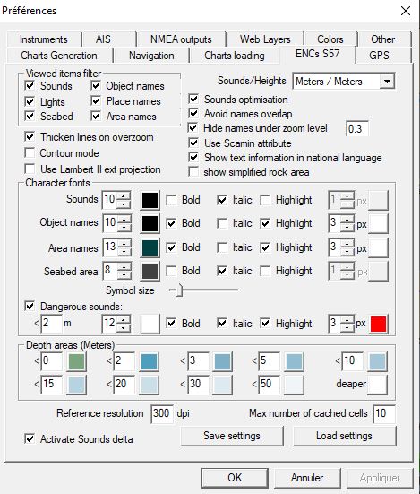 - "Viewed items filter"
lets you filter certain chart features to have a lighter
display (unchecked features are hidden)
- "Viewed items filter"
lets you filter certain chart features to have a lighter
display (unchecked features are hidden)- "Sounds optimization" lets you eliminate deeper sounds when zooming out, so as to remain readable while keeping the most dangerous sounds.
- "Avoid names overlap" Eliminates texts that overlap when information is too dense, so as to keep a clear display.
- "Hide names under zoom level": Names will be hidden if zooming out under the given value, so as to keep things readable.
- "Use Scamin attribute": each chart object may contain an attribute "scamin" indicating not to display this object under a certain scale, so as to clarify the display. By unchecking this option, this attribute is ignored and these objects will display whatever the scale.
- "Show text information in national language": Names and other text information may be displayed either in English for all charts, or in language of the originating country of each ENC.
- "Show simplified rock area" will result in a faster, but less explicit display of rock areas.
- "Reference resolution": Lets you tune the resolution used to display ENCs at native scale. If you consider a 1/1 ratio, it will not be sufficient to render all details without overlapping due to screen technology which is around 72 to 96 dpi. A ratio of 2 or 3 will be more comfortable to see all details. It is very similar to paper charts that are scanned around 200dpi and displayed on screen that are around 72 to 96 dpi.
- "Max number of cached cells": number of cells that will be kept in memory so as not to have to reload when passing from one to the other, therefore increasing performances.
- "Character fonts": Lets you tune size / color / type and highlighting of different texts. You can also tune the size of symbols with the "Symbol Size" ruler.
- OverZoom: Users are often confused thinking that vector charts have infinite details when zooming in, which is totally false. A chart, vector, or raster, has always a compilation scale in which it was designed. In ScanNav, OverZoom is put in evidence by thickening contour lines, text, etc... The user can therefore visually realize (in addition to the scale indicated in the title bar) that no extra details is coming up when zooming too near, as he would see with raster charts. Although it is not recommended, this option can be deactivated by unchecking "Thicken lines on overzoom".
- "Contour Mode": Lets you overlap S57 charts to raster charts to check them or combine for example with Google screen shots (need to deactivate the automatic mode)
- "Use Lambert II ext projection": Lets you overlap ENCs on top of MrSid Aerial photos that are in Lambert projection. Warning: it is nevertheless strongly recommended to only use this possibility temporarily, and switch back to standard Mercator projection for navigation usage.
Starting from version 14.1, it is possible to choose Soundings and Heights units
in ENCs between Meters (default), Feet, or Fathom. This option not only
impacts the charts display, but also all fields related to deths and
heighs in the ENC settings, and also "dynamic sounds" units (see
below). It has nevertheless
no impact on the S57 charts information window which always displays
raw information as coded in the ENCs, so always in Meters.
Warning:
changing back and forth between units might engender rounding errors.
For example switch from Meters to Fathom then back to Meters might
change a value of 2m to 1.99m. On another side, the internal reference
in ENCs is expressed in Meters which is the IHO International standard,
including for countries using imperial units. This can lead to
display of soundings with an excess of precision.
Dynamic sounds:
- "Dangerous sounds": Lets you highlight sounds under a given value, to put them in evidence using specific text display. Important warning: Dangerous sounds will evolve according to the depth correction entered (see below)
- "Depth areas": Lets you customize colors for different depth areas. A tip is to enter in the first cell the minimum security depth with a specific color. All depths areas containing sounds above this value will therefore be be put in evidence, highlighted with the given color. Important warning: Depth areas will evolve according to the depth correction entered (see below)
- "Activate sounds delta":
This option activates the depth correction control 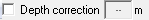 in the menu bar to
enable the dynamic sounds feature according to a water level at a given
time.
in the menu bar to
enable the dynamic sounds feature according to a water level at a given
time.
WARNING:
this feature modifies sounding values displayed on the chart.
The process is to enter the water level of the current tide. For
example, if you enter a value of 3m, a sound of "1" meter will be
displayed "4" meters, and will therefore not correspond to
the hydrografic zero anymore.
- 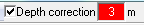 When the option "Depth correction" is checked with a value different to
0, the text field will be highlighted in red to signal that soundings
have been modified.
When the option "Depth correction" is checked with a value different to
0, the text field will be highlighted in red to signal that soundings
have been modified.
- 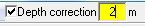 As soon as you start modifying the value, it will be highlighted in
yellow to indicate that a modification is pending, and that soundings
on the charts are therefore in an undetermined state. It will switch
back to red (or white if value is 0), as soon as you validate the
modification by hitting the "Enter" key, or clicking elsewhere, or
automatically after 5 seconds; and soundings on the chart will be
modified accordingly.
As soon as you start modifying the value, it will be highlighted in
yellow to indicate that a modification is pending, and that soundings
on the charts are therefore in an undetermined state. It will switch
back to red (or white if value is 0), as soon as you validate the
modification by hitting the "Enter" key, or clicking elsewhere, or
automatically after 5 seconds; and soundings on the chart will be
modified accordingly.
- By unchecking the option, the input field will switch
to gray, and soundings will be back to their standard values.
WARNING: This feature only concerns ENC/S57 charts.Soundings displayed on other types of charts (Navionics, rasters,...) are not affected. You must therefore be very careful when using different types of charts altogether. The "Activate sounds delta" control will only show up if some ENCs are present in you charts library.
Querying ENCs:
ENCs are designed with a vector technology, bringing additional
information for each object inside the chart (lights, buoys, sounds,
etc...) . All objects can be queried for additional information with
the following specific S57 information window. To open it, use
the ![]() icon, or menu "Option" -> "S57 info".
(refer to the general documentation to configure custom toolbars in
case
icon, or menu "Option" -> "S57 info".
(refer to the general documentation to configure custom toolbars in
case ![]() is not present)
is not present)
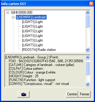
- When selecting a line, the corresponding object will be highlighted on the map, and textual information relative to this object will be listed in the bottom part of the dialog (for ex. light characteristics, sounding values, etc...)
- Certain objects have additional information in a separate text file. When this is the case, a button
 will show up at the bottom of
the window. Clicking on it will display the corresponding text file in
a separate window.
will show up at the bottom of
the window. Clicking on it will display the corresponding text file in
a separate window. - Other objects can also be associated to a photo or other illustration. In this case the button
 will show up and clicking
on it will show the photo in a new window.
will show up and clicking
on it will show the photo in a new window.- The window can be re-sized for more visibility, and proportion of the 2 sub-windows may be changed by dragging the separator.
Installation and management of ScanNav's Charts library
Starting from version 11.5, please refer to the installation guide in pdf format for a full description of the installation process. For older versions, please refer to the S63Install documentation (accessible from the Windows "start" menu, then in ScanNav folder)
Vector ENCs are managed in the same way as Raster charts (BSB, etc...) through the Charts Library. The library may contain a mix of Vector and Raster charts.
To insert a full pack of encrypted ENCs, you just have to insert the "enc.pmt" file from the ENC_ROOT directory, which will add all present ENCs in one step.
To insert non encrypted S57 files (such as free US S57 chart available at https://www.charts.noaa.gov/ENCs/ENCs.shtml), the process is similar, just use file "CATALOG.031" instead of "enc.pmt".